Drone dike inspection: from the single flight to a programme
Coverage, repeatability and an evidence trail — not sharper eyes. What operators must set up to turn drone flights over flood defences into a running inspection programme.
Inspecting flood defences takes more than isolated drone flights. A real programme needs structured change detection, a clear escalation path for AI findings, and deep integration into the asset management systems already in use.
Key Takeaways
- 1Drones do not replace expertise. What they add is the coverage that makes change detection over a time series possible at all.
- 2AI video analysis produces candidate findings; releasing them and routing them into GIS or CMMS stays with qualified staff.
- 3The EASA operating authorisation for complex flights is a continuing process that sits organisationally outside the drone hardware.
The end of the single flight: why flood defence needs a programme
The debate about uncrewed aircraft over linear hydraulic infrastructure is dominated by a technological fallacy: the assumption that cameras and algorithms identify cracks or defects on a dike body more precisely than trained staff on the ground.
The operators themselves put it more soberly. In its public material on the 2026 drought, the Dutch Hoogheemraadschap Hollands Noorderkwartier writes that drones are used to detect cracks, but that this only works “if cracks are visible from above, when there is no high or mown grass on the dike” – and that its inspections continue to be walked in pairs. Optical sensing is not, therefore, superior to an experienced inspector at the initial detection of a drought crack in an earth body.
The operational shift lies elsewhere: in coverage, temporal reproducibility and a defensible evidence trail. Flood defences are wide-area linear assets under permanent environmental load.
For the Netherlands the order of magnitude is a matter of public record: the national association Unie van Waterschappen states “bijna 17.000 km waterkeringen” – just under 17,000 kilometres of flood defences, a term that covers not only dikes but also dunes, dams, quays and locks. Of that, the 21 regional water authorities are responsible for roughly 3,600 kilometres of primary defences and some 14,000 kilometres of regional defences; Rijkswaterstaat looks after the remaining three percent or so of the primary works. For Germany there is no equivalent figure from the asset owners: flood protection is a matter for the federal states, and no nationwide register is published. The only freely available total comes from the insurance association Gesamtverband der Deutschen Versicherungswirtschaft (GDV), which cites, without attribution, “etwa 6.300 Deiche mit einer Länge von rund 13.300 Kilometern” – about 6,300 dikes totalling around 13,300 kilometres (as of 4 February 2025). Anyone planning against that number should know it is the insurers' figure, not an operators' cadastre.
These dimensions make the point: manual visual inspection on foot or by vehicle runs into limits of staff and time. A single flight delivers nothing more than an isolated snapshot – which is as true for dike lines as it is for deformation and seepage monitoring on dams and reservoirs or for bridge soffit inspection without a closure, where the same programme logic applies. Operators have to make the step from a project-based trial to a standardised inspection programme.
- Coverage: gap-free capture of hundreds of route kilometres at consistent data density, including the hard-to-reach fore- and hinterland.
- Repeatability: identical flight paths and camera angles via standardised waypoints, so condition comparisons actually compare.
- Evidence trail: audit-proof documentation of every change of condition, as proof against the monitoring duties that DIN 19712 “Hochwasserschutzanlagen an Fließgewässern” (edition 2013-01) assigns to the operator.
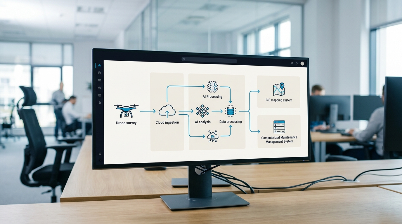
A viable programme is defined not by the aircraft but by the full life cycle of the data: from flight planning through automated analysis to conversion into maintenance work orders. From a vendor-independent integrator's seat, drones are standardised data capture devices whose value only appears once they are embedded in the water authority's operating processes.
Cadence and triggers: when and why you fly
An operational inspection programme for flood defences rests on a two-tier architecture: a fixed base cadence for routine condition monitoring, and a defined set of event-driven triggers.
The technical requirements for planning, construction and operation of such works are set out in the relevant codes of practice – in particular DWA-M 507-1 “Deiche an Fließgewässern, Teil 1: Planung, Bau und Betrieb” (edition December 2011), which according to its abstract explicitly gives guidance on dike maintenance, dike monitoring and dike defence, and in DIN 19712 “Hochwasserschutzanlagen an Fließgewässern”. The specific cadence is set by the operator in its operating manual, typically so that the base condition of the grass cover, the slope geometry and the crest tracks is fully captured after the frost period and before the typical high-water months.
Alongside the base cadence, changing climate conditions and operational events call for flexible additional flights. Extended drought withdraws moisture from clay- and peat-bearing dike bodies and provokes deep shrinkage cracks, while heavy rainfall can create surface erosion channels. After a flood peak has passed, the landward slope must be checked without delay for seepage or incipient slips. Structural work on the cross-section or changed land use in the protection strip triggers a targeted survey in the same way.
| Event type | Operational trigger | Primary inspection focus |
|---|---|---|
| Cyclical spring flight | Routine review after the winter period | Vegetation gaps, burrowing damage, frost break-up |
| Cyclical autumn flight | Routine preparation for the flood season | Profile geometry, crest condition, track infrastructure |
| Drought and heat periods | Soil moisture below threshold | Drought cracks, shrinkage fissures in the dike core |
| After a flood event | Passage of the flood peak | Seepage points, washouts, slope slips |
| Structural intervention | Completion of civil or remediation works | As-built comparison of geometry, compaction state |
Defining these triggers in the operating manual makes sure flights do not happen ad hoc on subjective judgement. For the authority it produces a plannable operating frame that synchronises approvals, staff resources and downstream processes in advance.
Change detection: reading a time series, not a snapshot
The isolated data set of a single drone flight has limited value for long-term asset management. Orthophotos or 3D models without a temporal reference document the current state but support no defensible statement about how damage is developing. Only a systematic before-and-after comparison across a time series – multi-temporal change detection – turns raw data into a predictive maintenance instrument.
Reliable automated change detection depends on sub-centimetre georeferencing. If flight paths and camera orientations are not reproduced exactly via RTK- and PPK-supported GNSS, small deviations in image alignment produce faulty difference models. Point clouds and digital terrain models have to be calibrated against fixed ground control points or standardised reference networks so that algorithmic comparison can separate real structural change from measurement noise.
- Settlement and subsidence detection: millimetre-level identification of sinking crests or unstable slope sections by comparing successive elevation models.
- Erosion monitoring: early detection of soil loss on water- and landward slopes before critical flow channels form.
- Vegetation analysis: capture of woody growth and root penetration in the protection strip that threatens the tightness of the earth body.
- Seepage tracking: thermographic and multispectral monitoring of damp slope areas to detect changed seepage patterns.
Automated differencing makes slow degradation visible long before it would be noticed by eye during a walk-over. That lets asset managers schedule remediation on the basis of budget and condition rather than reacting to acute damage.
Triage and escalation: who owns an AI finding?
Automated image recognition models are capable tools for pre-filtering large data volumes, but they make no legally or technically binding maintenance decisions. An algorithm produces candidate findings with an assigned confidence, nothing more. Operational responsibility for assessing and releasing them stays with the water authority's qualified staff.
A working inspection programme therefore needs a clearly structured triage. When a potential crack, a vegetation defect or a settlement is flagged, the candidate runs through a defined review path. Only after technical confirmation by the responsible dike engineer does a data point become an official defect that turns into a remediation instruction.
- Candidate generation: the analysis algorithm marks anomalies in the georeferenced imagery and assigns a damage category and a statistical likelihood.
- Technical review (triage): a qualified assessor verifies the candidate in the dashboard against historical flight data and rules out false positives from shadow or vegetation.
- Severity assessment: classification of the verified defect against standard criteria – non-critical surface disturbance, anomaly requiring observation, or acute threat to stability.
- Action trigger: handover to the maintenance team with a defined response window and automatic generation of the work order.
Without this governance the introduction of AI-supported drone systems reliably overloads the organisation with unfiltered alerts. The programme is what makes ownership of a finding and the authority to decide unambiguous.
Integration into the asset register: GIS, CMMS and EAM
An inspection finding stored as a PDF report or an image file on a local drive achieves nothing. To secure the operation of flood defences durably, drone data has to flow in structured form into the organisation's systems of record: geographic information systems (GIS), computerised maintenance management systems (CMMS) and enterprise asset management (EAM).
Integrated solutions covering this flow exist on the market. Siemens lists the drone operations and intelligence platform of the vendor Aerosophia in its own product catalogue as a solution for water management and dike inspection. According to the Siemens product description – cited here purely as a publicly documented market example – the solution uses AI analysis to identify cracks, erosion, subsidence, vegetation overgrowth and pipeline anomalies, processes drone imagery into 3D point clouds for digital-twin viewing, compares repeat flights in multi-temporal change detection, and passes georeferenced findings to existing CMMS, GIS and asset management environments; Siemens Brightly, IBM Maximo, GeoWeb, ProcessPro and ArcGIS are named among them. As a use case Siemens names the Dutch Waterschap Hollandse Delta, where the platform is used both for dike inspections and for inspecting waste water pressure pipes.
What decides the outcome is the link between the geodetic position and the unique object code in the authority's asset register. Only when a finding is bound to the specific dike segment, the chainage and the component can historical repair costs, warranty periods and regulatory reporting duties be traced without gaps.
The operating authorisation: the frame that sits outside the hardware
Buying capable drone and sensor technology is the smallest part of the hurdle. The real operational bottleneck is the aviation approval process for linear infrastructure flights. Flying along hundreds of kilometres of dike line is economic only beyond the remote pilot's visual line of sight (BVLOS).
The regulatory frame is set by Commission Implementing Regulation (EU) 2019/947 and the guidance of the European Union Aviation Safety Agency (EASA). While standard scenarios in the open category suffice for simple visual-line-of-sight work, linear BVLOS inspection falls squarely into the specific category. That requires a risk assessment under the SORA method (Specific Operations Risk Assessment), carried in the AMC and GM to Regulation (EU) 2019/947; ground and air risk have to be demonstrated through to the resulting SAIL. The current version, SORA 2.5, was taken into the AMC and GM by ED Decision 2025/018/R.
- Concept of operations (ConOps): flight corridors, contingency procedures, diversion landing areas and communication links along the watercourse.
- SORA risk analysis: determination of the Ground Risk Class (GRC) and Air Risk Class (ARC) to establish the required SAIL.
- Demonstration of compliance: ground station certification, resilience of the data links and qualification of operating staff towards the competent authority.
This authorisation hangs on no purchasing decision. It is issued against an operation, not against an aircraft, and it stays with whoever actually conducts the flights – whether that is the authority itself or a contracted operator is a question of operating model, not of procurement. wedrone, the aerial unit of the werob family, works here as an integrator: it helps specify the concept of operations and the requirements on aircraft, data link and ground station so that they fit the intended approval route. Neither werob nor wedrone applies for or holds that authorisation on the operator's behalf. How the route through the specific category runs in detail is covered in our article on BVLOS approval.
From concept to operation: what integration actually has to close
Moving drone technology out of isolated innovation projects and into permanent area-wide operation rarely fails on the capability of individual components. It fails on fragmented interfaces between hardware, data processing, asset management and regulatory obligation. The job of a vendor-independent integrator is to join those disciplines into one consistent, audit-proof whole.
Successful end-to-end integration decouples the water authority from individual hardware manufacturers and creates an operating architecture that survives a generation change. The same argument applies across the aerial inspection portfolio, from power line and infrastructure inspection to environmental monitoring; where an authority does not want to run the flights itself, drone-as-a-service as an operating model is the alternative worth examining.
- Vendor-independent sensor selection: matching the payload (RGB, LiDAR, thermography) to the specific soil formations and vegetation zones.
- Standardised interfaces: connecting proprietary drone data to central EAM, GIS and ERP infrastructure without vendor lock-in.
- Operational scaling: standardised operating procedures for uninterrupted routine use across the whole area of responsibility.
Flood protection is a core public duty. Moving from situational single flights to an industrialised inspection programme lets water authorities secure the resilience of their works, reduce the walk-over burden on staff, and establish a defensible evidence chain across the full life cycle of the structures.
FAQ
- What is the most important trigger for unscheduled dike inspections?
- Alongside the fixed cadence, drought, heavy rainfall, a recent flood event or construction work on the structure all call for prompt flights to identify acute cracks or settlement.
- How long is the dike network that has to be monitored?
- For the Netherlands the Unie van Waterschappen reports just under 17,000 kilometres of flood defences, of which around 3,600 kilometres of primary and some 14,000 kilometres of regional works are the responsibility of the 21 water authorities. There is no comparable operator figure for Germany; the insurance association GDV cites about 6,300 dikes totalling around 13,300 kilometres (as of 4 February 2025).
- Does AI analysis replace human staff on drone flights?
- No. The AI only generates candidate anomalies. Triage, technical assessment and the decision to act remain with the asset manager or the maintenance leads on site.
- How are findings from drone inspection processed?
- A finding is only usable once it enters the asset register georeferenced. Publicly documented platforms such as the Aerosophia solution listed by Siemens bind AI results directly into CMMS or GIS systems so the workflow has no break in it.
- What role does SORA play in dike inspection?
- SORA (Specific Operations Risk Assessment) is the risk assessment method carried in the EASA AMC and GM for the specific category, and therefore for flights beyond visual line of sight. Because dikes are linear structures, efficient inspection requires the corresponding authorisation under Regulation (EU) 2019/947.
Related reading
Drone-based bridge inspection: reaching the soffit without a closure
Learn how drone bridge inspection accesses soffits and bearings under DIN 1076 without closures, helping overcome construction skilled worker shortages.
17 July 2026drone dam inspectionMonitoring dams and reservoirs from the air: deformation and seepage over time
Learn how the wedrone platform standardizes multi-pass aerial monitoring to detect structural deformation and dam seepage over time with millimeter precision.
17 July 2026drone as a service the operating model thatDrone-as-a-Service: the operating model that turns drone pilots into routine programs
Discover how Drone-as-a-Service converts manual pilots into routine programs. Scale your operations legally under EU regulation 2019/947 with wedrone.
7 July 2026onboard drone autonomyOnboard Drone Autonomy: What Changes for Operators
The question is not whether the aircraft can fly itself. It is what you have to be able to show once it does — indoors, on containment, on link loss, and in procurement.
31 August 2026power line and infrastructure inspection with dronesPower Line and Infrastructure Inspection with Drones: Thermography, BVLOS Corridors and Data Products
Learn how drone thermography and BVLOS corridors optimize power line inspections under EU regulation 2019/947, from planning to routine operations.
8 July 2026