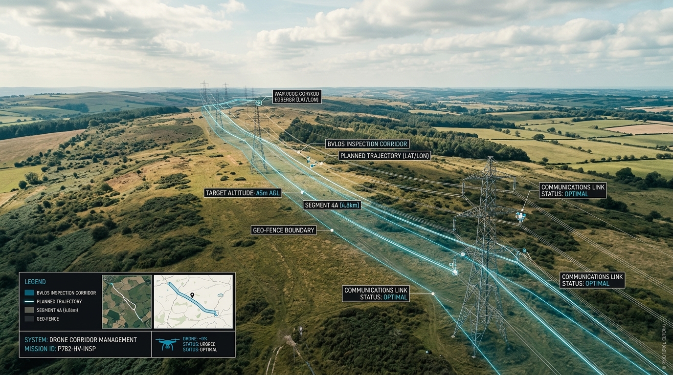
Power Line and Infrastructure Inspection with Drones: Thermography, BVLOS Corridors and Data Products
Learn how drone thermography and BVLOS corridors optimize power line inspections under EU regulation 2019/947, from planning to routine operations.
Modern power line inspection relies on drone thermography and BVLOS corridors to replace high-risk manual work. Transitioning to automated routine operations under EU regulation 2019/947 requires a manufacturer-independent platform to unify data and physical infrastructure.
Key Takeaways
- 1Drone inspections save an average of 40 percent on operational costs compared to traditional utility survey methods.
- 2Thermal cameras will capture a projected 39.6 percent of the inspection drone market by 2026 as heat diagnostics become standard.
- 3Industrial inspection drones offer an operational range of up to 20 km, enabling efficient beyond visual line of sight corridor flights.
- 4Autonomous flight automation increases field efficiency, allowing pilots to inspect up to 50 kilometers of power lines per day.
The Shift to Drone-Based Utility and Power Line Inspections
Maintaining the structural integrity of electrical grids and high-voltage transmission lines has traditionally relied on high-risk manual climbs and expensive helicopter-based aerial surveys. These older methods present substantial operational hazards for field technicians, require complex logistics, and demand extensive downtime. As utility companies work to modernize grid maintenance, automated drone technology is increasingly replacing these legacy inspection workflows. By transitioning from manual inspections to automated aerial systems, utilities can drastically reduce human exposure to high-voltage environments while generating high-fidelity data that traditional methods cannot easily replicate.
The operational transition to unmanned aerial vehicles (UAVs) delivers quantifiable economic and safety improvements. Aerial inspections not only eliminate the hazards of manual climbs but also reduce overall inspection costs. Industry data shows that adopting drone-assisted inspection workflows can save utility operators an average of 40 percent in overall inspection and remediation costs compared to traditional ground and manned aviation methods. This cost reduction is achieved by speeding up data collection timelines, removing the need for heavy ground equipment or manned aircraft, and preventing catastrophic grid failures through early anomaly detection.
From Isolated Use Cases to Unified Routine Operations
While many operators have tested drones as isolated, experimental use cases, scaling these initiatives into a predictable, routine program requires a structured systems integration approach. This is where wedrone, the specialized drone unit of werob, acts as a manufacturer-independent systems integrator. Rather than relying on a single drone manufacturer or proprietary software, utilities can leverage the werob Platform to plan, source, integrate, and continuously monitor their aerial fleets. The werob Platform connects diverse robotic hardware with existing enterprise systems, facilitating a seamless transition from proof-of-concept tests to daily, standardized utility inspections.
- Reduced physical hazards: Technicians remain safely on the ground, avoiding high-voltage tower climbs and reducing workplace injuries.
- Lower operational costs: Eliminating manned helicopter flights and heavy ground logistics drives down the cost of inspecting long-distance power corridors.
- High-resolution data capture: Equipped with advanced optical and thermal payloads, drones capture minute physical defects and thermal anomalies that are invisible from the ground.
- Rapid deployment and scalability: Automated flight planning allows operators to cover thousands of miles of transmission lines systematically.
To maintain absolute control over scaled operations, utility decision makers and drone operators require real-time visibility. Through the unified Cockpit dashboard, users can track hardware health, infrastructure readiness, regulatory compliance, and specific operational requirements in one place. The Cockpit provides a centralized, traffic-light-monitored dashboard that aggregates telemetry, audit logs, and mission data, ensuring that every flight operates within safe parameters. By combining this consolidated visibility with a manufacturer-independent partner network, utilities can build a reliable inspection pipeline that operates smoothly under complex regulatory frameworks.
Thermographic Analysis for Grid Maintenance and Hot Spot Detection
Utility infrastructure requires continuous, high-precision monitoring to maintain grid stability and prevent localized outages. Integrating thermographic analysis into drone-based inspections allows operators to capture thermal radiation and identify localized anomalies, such as overheating connectors, failing insulators, or overloaded transformers, long before a catastrophic hardware failure occurs. By capturing high-resolution infrared data, technical teams can pinpoint precise coordinates of thermal stress. This systematic approach transitions grid maintenance from reactive repair schedules to highly targeted, predictive maintenance routines.
The operational value of integrating infrared sensors is reflected in industry adoption trends. Thermal cameras are projected to capture a 39.6 percent share of the inspection drone market by 2026. This growing reliance highlights the shift from visual-only inspections to multi-sensor payloads capable of diagnosing hidden structural and electrical stresses. To utilize these advanced sensors effectively, operators are combining thermal analysis with beyond visual line of sight (BVLOS) flights. This setup enables long-range corridor monitoring over miles of transmission lines in a single operational window.
Transitioning from Manual Inspections to Routine Operations
Scaling these thermal inspections across expansive grids requires a cohesive software and partner ecosystem. Rather than relying on isolated hardware or individual pilots, utilities use the werob Platform to manage the entire lifecycle from planning to continuous monitoring. Through the Supplier Match engine, operators can select qualified hardware and regulatory-ready drone service providers within a manufacturer-independent partner network. Compliance with EU drone regulation 2019/947 is integrated directly into the planning phase, enabling operators to secure authorizations for complex BVLOS corridors through specialized regulatory partners.
During active missions, telemetry and sensor feeds are unified within a single Cockpit dashboard. This centralized monitoring tool provides real-time traffic lights across multiple operational dimensions, including hardware health, infrastructure status, regulatory compliance, and action specs. By funneling thermal imaging data directly into this centralized interface, utility operators can coordinate flights, track pilot training, monitor airspace safety, and generate standardized data products for maintenance crews. For permanent installations and automated operations, wedrone also integrates drone landing pads, including Pad Home, Pad Business, and Pad Med, directly into the infrastructure grid to support automated charging and deployment.
- Georeferenced thermal orthomosaics that overlay temperature profiles onto high-resolution physical grid maps
- Automated hot spot detection reports pinpointing components exceeding critical thermal thresholds
- Three-dimensional thermal models of substation infrastructure for localized stress analysis
- Standardized diagnostic logs compatible with existing utility enterprise asset management systems
Unlocking Large-Scale Efficiency with BVLOS Corridors
Traditional grid inspections often rely on ground crews manually moving from tower to tower or on manned helicopter sorties that carry high costs and inherent safety risks. Transitioning to Beyond Visual Line of Sight (BVLOS) flight operations allows utility operators to map extensive stretches of power line and pipeline infrastructure without constant manual team relocation. Utilizing advanced drone models that achieve an operational range of up to 20 km per flight, operators can cover multiple transmission towers and pipeline segments in a single mission. As a manufacturer-independent systems integrator, wedrone integrates diverse hardware options and software layers, transitioning inspections from isolated, manual use cases into highly automated routine operations managed via the werob Platform.
The Operational Advantages of BVLOS Operations
BVLOS corridors optimize data collection by maximizing flight time and reducing the overhead associated with frequent launches and landings. By eliminating the constraint of keeping the drone within the pilot's visual line of sight, utility operators can plan continuous paths along electrical corridors, collecting high-resolution visual and thermal data. This continuous capture is critical for creating consistent orthomosaics and 3D LiDAR models of the infrastructure, which are used to inspect conductors, detect hotspots, and monitor vegetation clearance. To support automated routines, wedrone landing pads, such as Pad Business, can be deployed along the corridor to act as automated charging stations, facilitating fully autonomous, remote-controlled cycles.
- Corridor Efficiency: Drones can cover long, linear infrastructure assets in fewer flights, drastically reducing the time spent on manual setup and team relocation.
- Data Continuity: Continuous flight paths provide uniform visual and thermal datasets, minimizing calibration discrepancies between separate flight sessions.
- Resource Optimization: Field teams can monitor flights from a centralized location, lowering travel costs and removing workers from hazardous environments near energized lines.
Ensuring Regulatory Compliance and Unified Monitoring
Executing BVLOS flights in Europe requires strict compliance with EU drone regulation 2019/947. To navigate this complex regulatory landscape, wedrone collaborates with specialised partners to secure necessary operating permits and conduct specific operations risk assessments (SORA). Rather than managing these regulatory and operational layers in isolation, operators can monitor all flight dimensions in real time. Through Cockpit, a unified monitoring dashboard developed by werob, decision makers get use-case-level traffic lights spanning hardware, infrastructure, regulatory, and spec parameters. This centralizes audit logs, tasks, and flight statuses, ensuring that large-scale BVLOS corridor inspections remain compliant, safe, and efficient.
Regulatory Compliance under EU Regulation 2019/947
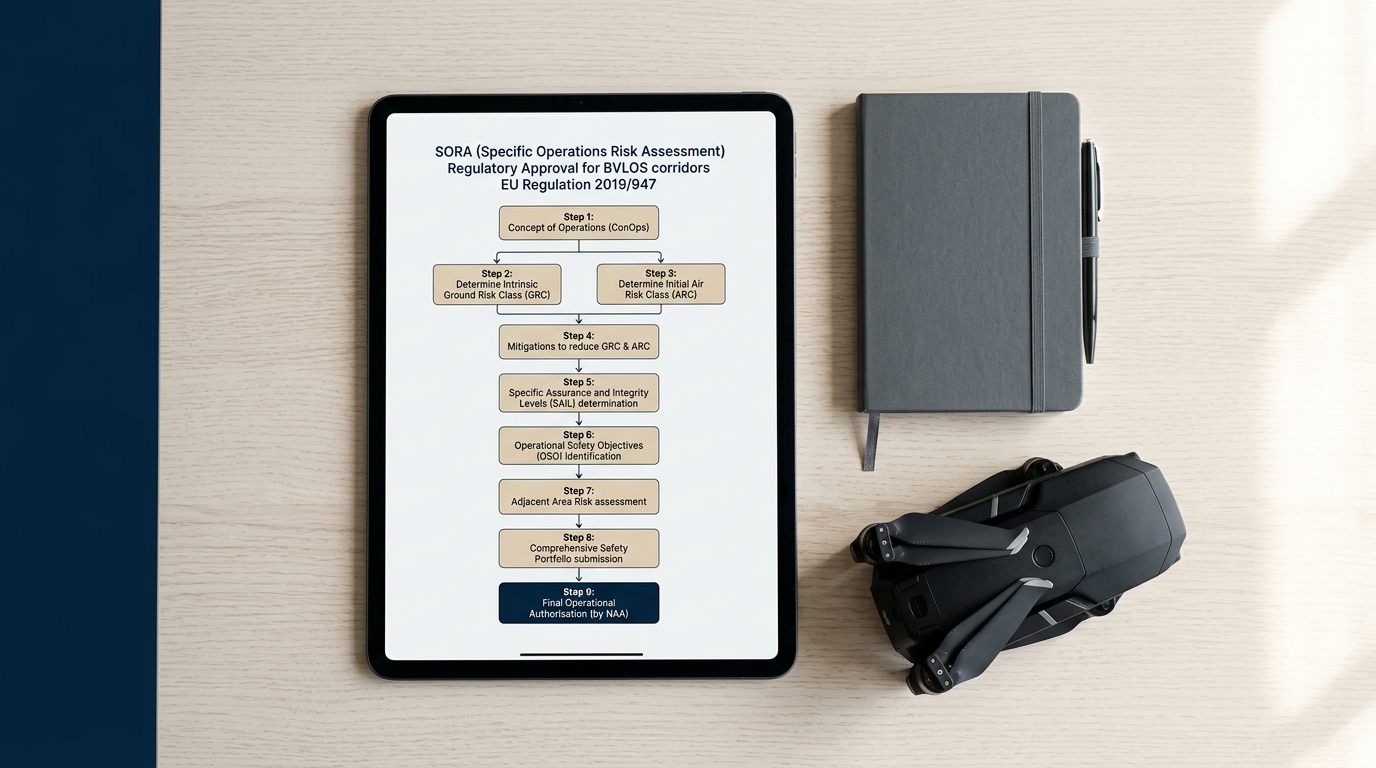
Scaling drone operations from isolated pilot projects to routine utility inspections requires a rigorous approach to European airspace regulations. Under Commission Implementing Regulation (EU) 2019/947, complex activities such as long-range Beyond Visual Line of Sight (BVLOS) power line inspections fall squarely into the 'specific' category of operations. This legal framework shifts the focus from simple weight-based rules to a comprehensive, risk-based safety assessment. For utility operators, navigating this regulatory landscape is a critical prerequisite before any thermal sensor can collect actionable data over critical infrastructure.
The SORA Framework and BVLOS Corridor Authorisations
To secure an operational authorisation for a BVLOS corridor, operators must execute a Specific Operations Risk Assessment (SORA) in accordance with Article 11 of Regulation (EU) 2019/947. The SORA methodology evaluates both ground risk (the population density under the flight path) and air risk (the likelihood of encountering other aircraft). Determining these factors demands specialized geodata and operational expertise, which is why wedrone collaborates with a manufacturer-independent partner network to streamline the approval process. By coordinating with designated aviation experts and national authorities, the werob Platform helps operators establish compliant flight corridors that transition drone-based thermography from single use cases into recurring enterprise workflows.
- Ground Risk Class (GRC) Mitigation: Implementing technical safeguards like active parachute systems and impact energy reduction measures to lower the operational risk level.
- Air Risk Class (ARC) Management: Utilizing electronic visibility systems, such as FLARM or ADS-B transponders, to satisfy airspace observer requirements in non-segregated airspace.
- Pre-defined Risk Assessments (PDRA): Leveraging existing European standard scenarios or PDRAs where applicable to bypass lengthy individual SORA applications for common utility corridors.
Managing these continuous regulatory parameters is integrated directly into daily operations. Within the werob Platform, the Cockpit serves as the central operations interface. This unified dashboard provides real-time traffic lights across multiple dimensions, including regulatory status, hardware health, and operational specifications. This ensures that every flight executed along a power line corridor complies with active approvals and that any regulatory expirations are flagged well before take-off. Through this integrated approach, utility operators can confidently maintain safe, legal, and continuous infrastructure inspections.
From Manual Flights to Autonomous Routine Operations
Traditional utility grid inspections have long relied on manual drone piloting, which presents significant scaling bottlenecks. Manual flights demand continuous visual line of sight and high pilot concentration, often resulting in inconsistent data capture and limited daily range. By transitioning to automated flight patterns, operators can achieve consistent sensor angles and repeatable imaging path coordinates. This level of standardization is essential for advanced data products, particularly in drone thermography where minor variations in angle or distance can distort thermal measurements. When operations transition from custom manual flights to routine, automated procedures, utility companies can scale their inspection programs without a linear increase in headcount.
In a manual or semi-automated setup, a field team can only cover a fraction of a regional grid each day. The integration of beyond visual line of sight (BVLOS) corridors changes this dynamic entirely. Automated flight planning allows a single pilot to supervise multiple pre-programmed legs, drastically increasing the daily inspection footprint. Depending on asset density, terrain, and the specific payload configuration, automated drone systems can successfully inspect up to 50 kilometers of high-voltage or medium-voltage power lines per pilot per day. This shift represents a threefold increase in efficiency compared to manual operations, making the regular, proactive monitoring of massive distribution networks commercially viable.
Structuring the Operational Pipeline
Transitioning to autonomous routine operations requires a unified backend that handles everything from initial flight planning to final data analysis. Rather than managing isolated software tools for different drone models, operators can leverage the werob Platform. As a manufacturer-independent systems integrator, wedrone connects diverse hardware components and software systems into a single workflow. All operational dimensions, including hardware status, regional regulatory compliance, and mission specifications, are supervised from a single, unified Cockpit. This dashboard simplifies fleet monitoring, ensuring that every BVLOS corridor flight adheres strictly to EU drone regulation 2019/947 and specific operational authorizations.
- Pre-flight planning: System automatically ingests geographic and LiDAR data of the power line corridor.
- Action graph generation: Automated translation of route parameters into collision-free flight paths.
- Execution: The drone conducts the BVLOS flight path autonomously, collecting synchronized thermography and optical data.
- Data ingestion: Captured images and thermal files are uploaded and structured for rapid analysis in the central dashboard.
By replacing subjective manual flight execution with standardized, automated patterns, utility operators secure the objective data foundation required for predictive maintenance. Whether identifying localized thermal anomalies on conductors or documenting physical structural degradation, the transition to autonomous routine flights turns drone operations from an experimental technology into an everyday industrial utility.
Unified Operations with the Cockpit Platform and Connected Landing Pads
Scaling aerial infrastructure monitoring from isolated, pilot-dependent test flights into structured, continuous utility inspections requires a shift toward unified hardware and software integration. Rather than operating in technical silos, utilities can leverage the werob Platform to coordinate complex, multi-site robotic deployments under a single operational umbrella. As the manufacturer-independent drone unit of, wedrone functions as a specialized systems integrator, selecting the optimal drone platforms and sensor suites to execute highly detailed thermographic scans and BVLOS corridor inspections. This objective, brand-agnostic approach ensures that grid operators are never locked into a single drone manufacturer or proprietary software ecosystem.
Real-Time Fleet Orchestration via Cockpit
To monitor large-scale inspections of high-voltage transmission lines across dozens of kilometers, operators require continuous oversight of flight safety, system health, and regulatory compliance. The Cockpit dashboard addresses this complexity by consolidating multiple streams of telemetry and operational metrics into a unified view. Featuring use-case-level traffic lights across four essential dimensions (hardware, infrastructure, regulatory, and specification), Cockpit enables remote dispatchers to instantly check fleet readiness, assign ad-hoc inspection tasks, verify pilot training progress, track active escalations, and maintain precise audit logs. If an unexpected airspace restriction or hardware anomaly occurs, the dashboard displays real-time alerts so that operations managers can intervene immediately and maintain complete oversight.
Automating Ground Logistics and Data Integration
Continuous, autonomous drone operations are only as reliable as the ground infrastructure supporting them. Through automated drone landing pads such as Pad Home, Pad Business, and Pad Med, wedrone automates critical ground logistics, including weather-protected sheltering, precision landing guidance, and automatic battery charging. These physical hubs allow unmanned aircraft systems to deploy autonomously, complete their planned thermography routes, and safely return without requiring a local pilot on site. Once the drone lands, the collected sensor data is instantly routed through integration layers known as Connectors. These multi-tenant integration layers connect drone data streams directly with standard database stacks, ensuring that newly identified grid anomalies automatically trigger maintenance tickets and technical review workflows.
- werob Platform: The underlying systems integration platform that handles planning, sourcing, integration, and continuous monitoring to take autonomous systems from use case to routine operation.
- Cockpit Dashboard: A unified monitoring hub with four-dimensional traffic lights (hardware, infrastructure, regulatory, and specification) alongside audit logging and escalation pathways.
- Connectors Middleware: Pre-built, multi-tenant integration layers that connect robotic systems with existing operator databases and enterprise stacks like SAP EWM.
- Automated Landing Pads (Pad Home, Pad Business, Pad Med): Physical, weather-resistant landing docks that automate charging, sheltering, and local launch sequences for remote drone-in-a-box workflows.
By pairing flexible, manufacturer-independent systems integration with centralized software orchestration, grid operators can transition from experimental BVLOS projects to highly reliable, automated asset management programs. The combination of automated ground docking stations, standardized database integrations, and structured monitoring tools ensures that every thermal anomaly is documented, processed, and resolved with minimal operational overhead.
Read more: the wedrone drone unit · Drone-as-a-Service · drone inventory in warehouses.
FAQ
- How much can utility companies save by switching to drone inspections?
- Utility companies save an average of 40 percent compared to traditional inspection methods like manned helicopters or physical line climbs. These savings are driven by faster data capture, reduced equipment rental costs, and the elimination of expensive lane or shoulder closures during roadside grid surveys.
- What is the role of thermography in power line inspections?
- Thermal cameras, projected to hold a 39.6 percent market share in the inspection drone sector by 2026, detect localized thermal anomalies or hot spots. These anomalies indicate loose electrical connections, overloaded circuits, or degrading components, allowing operators to perform preventive maintenance before a failure occurs.
- What are BVLOS corridors and why are they important for grids?
- Beyond Visual Line of Sight (BVLOS) corridors allow drones to fly extended distances along power lines without requiring the pilot to maintain eyes on the aircraft. This increases efficiency by allowing a typical industrial drone with a 20 km range to map several miles of grid infrastructure in a single flight.
- How does EU regulation 2019/947 affect BVLOS drone flights?
- EU regulation 2019/947 places long-range BVLOS operations in the specific category. This requires operators to conduct a thorough risk assessment or operate under predefined standard scenarios. Operating safely in this category requires specialised partners to secure the necessary flight authorizations.
- What is the daily efficiency of an automated drone inspection pilot?
- With automated flight paths and autonomous systems, a single drone operator can inspect up to 50 kilometers of power lines per day. This represents a massive increase in efficiency compared to manual drone piloting, which is more physically exhausting and yields less consistent data quality.
- How do automated landing pads support drone operations?
- Automated landing pads like Pad Home, Pad Business, and Pad Med act as secure ground stations for weatherproofing, charging, and data offloading. When integrated with software like the Cockpit and Connectors, they turn drones into a continuous, routine inspection system without manual ground intervention.
Related reading
Drone-as-a-Service: the operating model that turns drone pilots into routine programs
Discover how Drone-as-a-Service converts manual pilots into routine programs. Scale your operations legally under EU regulation 2019/947 with wedrone.
7 July 2026drone dike inspection programmeDrone dike inspection: from the single flight to a programme
Coverage, repeatability and an evidence trail — not sharper eyes. What operators must set up to turn drone flights over flood defences into a running inspection programme.
28 August 2026drone inventory in warehousesInventory drones in the warehouse: does the hall have a door to outside?
The market sells them as drones, and with the word comes the drone regulation. For operation inside buildings its core requirements expressly do not apply — and switching them off is what pulls a different body of law in. One question decides which.
9 September 2026onboard drone autonomyOnboard Drone Autonomy: What Changes for Operators
The question is not whether the aircraft can fly itself. It is what you have to be able to show once it does — indoors, on containment, on link loss, and in procurement.
31 August 2026power line vegetation management clearance corridorVegetation Management on Power-Line Corridors: Why Clearing Is a Legal Obligation
Germany carries roughly 37,900 km of extra-high-voltage grid, every kilometre inside a protection strip set by law. Vegetation that grows into that strip is not a maintenance nicety — it is an outage and wildfire risk.
18 September 2026