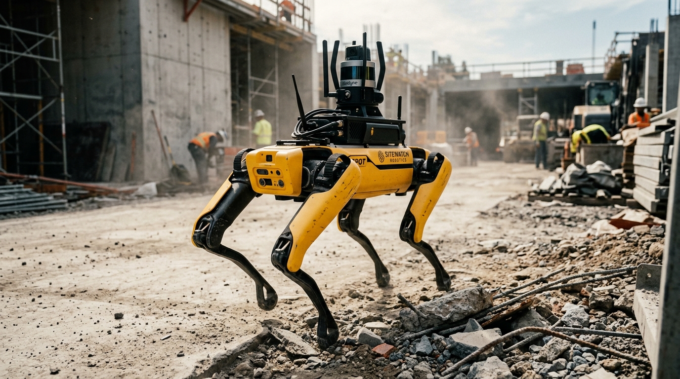
Autonomous Ground Survey with Legged Robots: As-Built and Progress as a Time Series
Discover how autonomous legged robots and high-precision laser scanners turn isolated site surveys into repeatable weekly progress time series.
Transforming isolated site surveys into continuous temporal insights. Autonomous legged robots equipped with high-precision laser scanners enable repeatable weekly progress tracking, helping building surveyors and infrastructure operators address severe labor shortages.
Key Takeaways
- 1German infrastructure requires immense monitoring across vast networks of bridges and wind turbines.
- 2Severe skilled-worker shortages in the construction industry make manual site surveys increasingly unscalable.
- 3Legged robots like Boston Dynamics Spot traverse complex, multi-level sites autonomously, unlike remote-controlled demolition robots.
- 4Integrating Leica or Trimble laser scanners on agile legged robots transforms static surveys into reliable temporal progress data.
The Shift from Snapshot to Time-Series Site Survey
Traditional as-built documentation typically relies on static, periodic snapshots that capture a single, isolated moment in time. For Building Surveyors and appraisers, who require precise structural tracking for valuations and quality controls, these infrequent scans fail to capture the active development of a construction site or the micro-movements of structural settling. Shifting to progress tracking as a continuous temporal series of spatial data points changes how we assess structural health. By walking identical routes on a weekly basis, mobile scanners record tiny, incremental changes over time, converting one-off inspections into actionable trend analyses.
It is critical to distinguish this ground-based autonomous approach from high-level aerial drone mapping. Broad-scale aerial solutions, such as those deployed by the wedrone unit, provide essential context and topography overviews for large project peripheries. However, they lack the high-density interior access and millimeter-level precision that terrestrial laser scanning delivers. As a manufacturer-independent robot integrator, werob designs dedicated workflows that send agile, legged platforms directly into changing indoor spaces. Walking the exact same paths weekly, the robots gather highly repeatable datasets that reveal internal structural variations before they turn into costly construction defects.
- Continuous temporal references: Consistent weekly routes guarantee that spatial comparisons are completely direct, eliminating positional and angle calibration offsets.
- Millimeter-level indoor precision: High-density terrestrial point clouds capture minute surface details that aerial mapping cannot resolve inside complex concrete or steel structures.
- Unified integration: Integrating systems like Boston Dynamics Spot with Trimble or Leica laser scanner payloads allows automated progress tracking without taking valuable human resources away from skilled onsite work.
The German Infrastructure Backlog and the Skilled-Worker Gap
Germany faces an unprecedented challenge in maintaining and modernizing its core physical assets. The country's critical infrastructure includes extensive networks of bridges on federal trunk roads, extra-high-voltage power grids, and active wind turbines. For building surveyors, appraisers, and asset owners, conducting regulatory safety assessments and keeping up with regular monitoring schedules across this immense national footprint has become a highly complex logistical task under traditional methods.
This soaring structural demand collides directly with severe labor constraints. Germany's 81,890 construction companies (HDB, June 2025) are struggling to fill critical technical roles, with the Main Association of the German Construction Industry forecasting a skilled-worker shortage of over 100,000 personnel by 2030 (HDB forecast 2022). Relying on manual surveying and physical inspectors to document site conditions and structural changes is increasingly unscalable, leaving operators in urgent need of modern automation solutions.
- Traditional physical surveys are limited by human capacity, slow transit times, and safety hazards on active sites.
- Aerial solutions like those from wedrone excel at wide-area mapping but cannot capture the dense, under-canopy, or indoor structural details needed for detailed as-built validation.
- Autonomous ground surveys utilizing legged quadruped platforms, such as Boston Dynamics Spot equipped with Leica or Trimble laser-scan payloads, present a highly repeatable solution.
- As a manufacturer-independent systems integrator, werob helps operators deploy these robotic assets to establish automated, weekly data-collection routines.
By partnering with an experienced Spot systems integrator like werob, enterprises can safely implement legged systems to execute precise, waypoint-driven patrols on a fixed schedule. Instead of isolated, manual snapshots, this continuous data capture builds a reliable as-built time series that directly transforms how structural progress is documented and verified.
Why Quadruped Robotics Outperform Traditional Ground Methods
Building surveyors and real estate appraisers face increasing pressure to document construction progress with precise, repeatable digital records. This challenge is intensified across Germany's 81,890 construction companies (HDB, June 2025) by an impending shortage of over 100,000 skilled workers by 2030 (HDB forecast 2022). Traditional manual surveying with terrestrial scanners mounted on tripods is slow and labor-intensive, while wheeled platforms fail on dynamic jobsites. Autonomous ground survey using quadruped robotics provides a continuous, highly accurate alternative.
- Fixed-route automation: The robot autonomously traverses the exact same waypoints on a predetermined route every week, ensuring highly consistent sensor perspectives.
- Unobstructed obstacle negotiation: Legged systems step over scattered site debris, climb steep stairs, and traverse mud or gravel that would block wheeled platforms.
- Sensor-payload flexibility: Carrying high-end laser scanners from manufacturers like Leica or Trimble, the robot captures millimeter-accurate point clouds of the exact same coordinate system.
- Data trend generation: Consistently repeating the identical route turns isolated, single scans into a continuous progress trend for long-term project analysis.
To achieve comprehensive site visibility, ground-level surveys must be clearly distinguished from aerial documentation. While aerial mapping is efficiently managed by drones through wedrone, ground-level indoor spaces and structural details require legged systems. As a manufacturer-independent robot integrator, werob handles the setup of mobile systems like the Boston Dynamics Spot by leveraging the werob Platform to connect the hardware with enterprise software and building databases.
Furthermore, true autonomy in site surveying should not be confused with other robotic applications on site. For example, demolition robots are remote-controlled, not autonomous. In contrast, autonomous quadrupeds require zero real-time human control to execute their weekly schedules. This continuous, structured data collection enables surveyors to compare the physical reality against BIM plans, providing verifiable evidence of the as-built and progress timeline.
The Hardware Stack: Integrating High-Precision Laser Payloads
Deploying autonomous ground surveys on complex construction sites requires a rigid physical and digital integration between the agile quadruped robot and the reality-capture instrument. As a manufacturer-independent automation partner rather than a hardware producer, werob specializes in assembling these multi-vendor hardware stacks. This role is crucial for Spot integration operations, where the robot acts as a mobile platform capable of navigating steps, debris, and mud that would block wheeled systems. By mounting high-end laser scanners directly onto the payload bay of the Boston Dynamics Spot chassis, building surveyors and appraisers can automate dense 3D point cloud collection. This terrestrial approach captures the fine details under overhangs and inside structures that aerial solutions, such as those provided by wedrone, cannot easily reach.
The hardware configuration pairs the legged robot with advanced scanners like the Leica BLK ARC, Leica RTC360, or Trimble X7. When mounted, these scanners communicate with the robot's onboard computer to trigger scans at predefined waypoints without human intervention. For instance, the Trimble X7 integrates directly with autonomous path controls to initiate a scanner rotation and level itself automatically at each stop. Meanwhile, the Leica BLK ARC provides a dedicated mobile scanning module that collects both static and walk-through LiDAR data, utilizing the robot's power source to maintain continuous operation. Because the robot returns to the exact same coordinates week after week, these single scans assemble into a highly precise, multi-temporal trend of site progress, which can be monitored remotely via the werob Platform.
- Payload Mounting: The laser scanner is bolted to the central payload rails of the robot dog using a dampening mount to isolate high-frequency vibrations during locomotion.
- Power and Control: A specialized wiring harness links the robot's auxiliary port to the scanner, supplying power and allowing the onboard software to coordinate the path with scan triggers.
- Waypoint Repeatability: The system uses autonomous navigation to stop at identical positions within millimeters, ensuring that weekly point clouds align perfectly for structural comparison.
Data Processing: From Static Point Clouds to Temporal Trends
Building surveyors and appraisers rely on high-fidelity, repeatable structural datasets to monitor structural integrity and progression over time. To achieve this, the data processing pipeline transforms raw static scans into a structured temporal series. When a Boston Dynamics Spot legged robot traverses the same waypoints weekly on a fixed ground route, it gathers dense 3D point clouds via integrated Leica or Trimble laser-scan payloads. Raw weekly point clouds are subsequently aligned using cloud-to-cloud registration algorithms like the Iterative Closest Point method, which iteratively rotates and translates overlapping spatial data to minimize point-to-point deviation. This precise alignment converts isolated, static snapshots into an evolving, four-dimensional temporal progress model.
- Detecting Millimeter-Scale Deformations: Multi-temporal comparison isolates minor physical structural shifts, indicating settling or load-bearing stress over months.
- Tracking Progress against BIM: Automated subtraction algorithms isolate as-built data from the as-planned Building Information Modeling database to track real-time construction progress.
- Distinguishing Ground and Aerial Contexts: Unlike aerial imagery mapped by our wedrone drone unit, ground-based quadruped laser scanning captures high-density details beneath ceiling slabs and behind columns.
Rather than acting as a hardware manufacturer, werob acts as an independent systems integrator, connecting these automated workflows directly to the client's internal software systems. Through the unified werob Platform, the generated temporal trends are automatically structured for analysis. This integration allows appraisers and project managers to view structural trends, detect physical defects, and review progress verification logs. By transforming raw spatial data into a dynamic time series, stakeholders gain verifiable as-built documentation that mitigates financial risk and enhances long-term quality control on complex infrastructure sites.
Simplifying Multi-Vendor Deployment with the werob Platform
Building surveyors face unprecedented headwinds in infrastructure management. Germany is managing a skilled-worker shortage forecasted to exceed 100,000+ professionals by 2030 (HDB forecast 2022), while maintaining critical assets like 40,264 bridges on federal trunk roads. While aerial inspection is routinely handled by drone operators like wedrone, ground-level site surveys demand a different approach. Autonomous legged robots carrying laser-scan payloads (such as Leica or Trimble) can walk fixed weekly routes along identical waypoints, turning individual scans into a consistent temporal trend.
However, deploying advanced robotics across active construction sites involves major operational barriers. As a manufacturer-independent systems integrator rather than a hardware producer, werob simplifies this process via the hardware-agnostic werob Platform. The deployment lifecycle begins with Spec Engine, which translates plain-language requirements into ROS-compatible action graphs within 48 hours. Following this, the Supplier Match engine analyzes a supplier graph of over 44 robot manufacturers to score and rank the optimal hardware based on regulatory readiness and price band.
After deployment, operations are continuously monitored via Cockpit. This unified dashboard tracks the fleet using use-case-level traffic lights across hardware, infrastructure, regulatory, and specification dimensions. By combining these independent technologies, surveyors can automate their weekly time-series captures without the risk of manufacturer lock-in.
- Spec Engine: Translates survey requirements into ROS-compatible action graphs within 48 hours.
- Supplier Match: Analyzes over 44 manufacturers to identify the optimal robotic hardware and payloads.
- Cockpit: Tracks active deployments via a unified dashboard with use-case-level traffic lights.
Operational Continuity and Enterprise API Middleware
Managing data on active construction sites is a notorious challenge for building surveyors and real estate appraisers. Across Germany, where 81,890 construction companies operate, projects are frequently plagued by fragmented documentation. Traditional site-survey workflows rely on manual data exports and physical storage drives. This manual handoff creates massive bottlenecks, delays critical structural evaluations, and isolates valuable spatial datasets from the core business systems that decision-makers rely on.
To establish true operational continuity, werob, acting as a manufacturer-independent robot integrator, implements Connectors. This specialized API middleware bridges mobile robotics directly with existing operator stacks, CAD software, and ERP systems such as SAP EWM. Instead of keeping spatial data trapped in siloed software, Connectors create an automated, real-time data pipeline. This pipeline streams high-fidelity spatial data collected by a Boston Dynamics Spot legged robot, equipped with laser-scan payloads from Leica or Trimble, straight into the operator database.
- Time-series generation: By walking a fixed route with identical waypoints every week, single laser scans are automatically compiled into a consistent progress trend.
- Ground and aerial coordination: While ground-level scans are captured by quadruped robots, aerial surveys can be managed through separate, specialized drone units like wedrone to maintain distinct operational domains.
- Large-scale infrastructure monitoring: This continuous pipeline is vital for tracking major structural assets, such as the 40,264 bridges on federal trunk roads, where manual inspections are too slow.
This continuous automation is becoming essential as Germany faces a forecast skilled-worker shortage of over 100,000 by 2030. By replacing manual scanning and tedious data reconciliation with verified, real-time survey insights, the werob Platform helps surveyors maintain rigorous as-built records. This structural intelligence enables appraisers and project leads to monitor progress and structural health with unprecedented precision, without adding to administrative overhead.
FAQ
- How do autonomous legged robots differ from drones in site surveys?
- While aerial drones (such as wedrone) excel at capturing high-level context and external envelopes, they lack the ability to navigate interiors or collect the ultra-dense, millimeter-accurate ground-level laser scans required for precise structural monitoring. Legged robots walk the ground on fixed routes, navigating through doors, around obstacles, and up staircases to capture consistent data from the same perspective week after week.
- How do legged robots solve the construction labor shortage in Germany?
- A forecast by HDB in 2022 predicts a skilled-worker shortage of over 100,000 by 2030 across 81,890 construction companies (HDB, June 2025). Automating repetitive, dangerous site surveys with quadruped robots frees skilled engineers from manual measurement tasks, allowing them to focus on high-value data analysis and quality control.
- Can legged robots monitor civil infrastructure like bridges and power grids?
- Yes. Germany manages extensive infrastructure, including 40,264 bridges on federal trunk roads (BASt, March 2026), 37,900 km of extra-high-voltage power grid (BNetzA, end 2024), and 30,906 wind turbines (end 2025). Legged robots provide a scalable solution for repeating high-precision laser scans across these vast, complex assets to track concrete degradation and structural shifting over time.
- Are demolition robots also fully autonomous like surveying quadrupeds?
- No. While legged surveying robots navigate sites autonomously on pre-planned routes, demolition robots are remote-controlled by human operators. Surveying quadrupeds use laser scanners (such as Leica or Trimble) and advanced obstacle-avoidance algorithms to walk independently, while hazardous demolition tasks still require manual, direct oversight.
- What is the role of werob in autonomous robotic deployment?
- werob is a manufacturer-independent robot integrator, not a robot manufacturer. Through the werob Platform, we coordinate the entire deployment lifecycle: Spec Engine translates shift requirements into ROS-compatible plans within 48 hours, Supplier Match identifies optimal hardware, and Cockpit offers real-time fleet monitoring.
- How is time-series laser scan data integrated into existing enterprise software?
- To prevent isolated data silos, integration middleware is required. The werob platform uses pre-built software layers called Connectors to feed multi-tenant data directly into existing databases and project management platforms (such as SAP EWM). This automates the pipeline from raw weekly point cloud generation to executive progress reports.
Related reading
Crane Time Is the Scarcest Resource: Which Construction Robots Need No Pick
The crane sets the tempo of the site, and it is not going autonomous in this planning cycle. So the useful question is not which robot lifts, but which one works without booking crane time — and which one competes for the hook or the airspace anyway.
2 September 2026autonomous trucks mining investment$310M Bet: Autonomous Trucks Make Stranded Mines Viable
Mariana Minerals raised $310 million to advance autonomous trucks in copper mining. Discover how autonomous haulage makes stranded mines economically viable.
18 August 2026robot commissioning on siteHow a robot learns your building: off-site vs on-site
Understand how robots learn to navigate your building, what vendors can train off-site, and why on-site integration dictates the commissioning schedule.
27 August 2026construction site theft surveillance robot drone night2,156 thefts, one in ten solved: what a construction site can establish at night, and what is not its job
The Baden-Württemberg state criminal police office counted a good two thousand thefts from construction sites and building shells in 2023, with almost ten million euros of damage, and about one case in ten was solved. The nationwide figures circulating beside that differ by a factor of six. From the numbers that hold up follows a task for the technology, and it is not to recognise the thief: it is to establish that something is happening on the ground, and to send someone.
16 September 2026layout robot construction siteLayout robots on site: printing BIM onto the slab to the millimetre
Discover how layout robots print BIM models directly onto concrete slabs with millimetre precision to eliminate manual errors and coordinate all trades.
17 July 2026